-40%
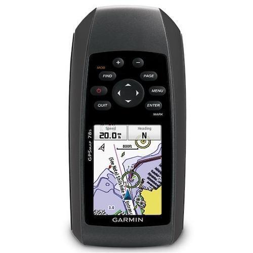
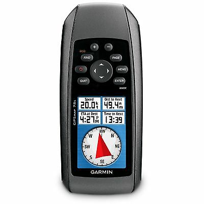
Garmin GPSMAP 78S Handheld Marine GPS Worldwide Navigation Chartplotter
$ 89.73
- Description
- Size Guide
Description
ExploreGPSMAP 78s comes with built-in worldwide basemap, so you can navigate anywhere with ease. And, like the rest of the 78-series, 78s is IPX7 waterproof and even floats in water. It also comes with a simple ‘Man overboard’ button that you press and hold to store your current location quickly as a waypoint and then begin navigating back to that point.
Get Your Bearings
GPSMAP 78s has a built-in 3-axis tilt-compensated electronic compass, which shows your heading even when you’re standing still, without holding it level. Its barometric altimeter tracks changes in pressure to pinpoint your precise altitude, and you can even use it to plot barometric pressure over time to keep an eye on changing weather conditions.
GPSMap 78s: Information At Your Fingertips
Share Wirelessly
With GPSMAP 78s you can share your waypoints, tracks, routes and geocaches wirelessly with other compatible device users. Now you can send the location of your favourite fishing spot to a friend to find. Sharing data is easy. Just press “send” to transfer your information to similar units.
Keep Your Fix
With its high-sensitivity, WAAS-enabled GPS receiver and HotFix satellite prediction, GPSMAP 78s locates your position quickly and precisely and maintains its GPS location even in heavy cover and built-up areas. The advantage is clear — whether you’re in dense woods or just near tall buildings and trees, you can count on GPSMAP 78s to help you find your way when you need it the most.
Add Maps
Adding more maps is easy with Garmin's wide array of detailed topographic, marine and road maps. Add BlueChart g2 preloaded cards for a great day on the water or City Navigator NT map data for turn-by-turn routing on roads including Europe and further afield. GPSMAP 78s also supports BirdsEye Satellite Imagery (subscription required), which lets you download satellite images to your device and integrate them with your maps.
You can conveniently plug in Garmin GB Discoverer mapping for OS Explorer (1:25k) and OS Landranger (1:50k) detail and hit the trail. The traditional look and feel of the Ordnance Survey map detail complements Garmin’s dynamic search capabilities. Use GPSMAP 78s to search, select and navigate to points of interest and street addresses and follow the route on foot, in the car or by bike with an Ordnance Survey backdrop.
In addition, the GPSMAP 78s is compatible with Custom Maps, free software that transforms paper and electronic maps into downloadable maps for your device. Put your favourite paper or digital maps on GPSMAP 78s by converting details, labels and landmarks from other maps and informal plans like ski piste routes, mountain bike trails or charity treks into tailored content that’s ready to navigate.
The card slot is located inside the waterproof battery compartment, so you don't have to worry about getting it wet.
Official Garmin Newly Overhauled Product
Newly Overhauled is when an item has been returned to Garmin for testing, it goes through a stringent 3 point check to ensure the item is in full working order, any part that needs replacing, is replaced to ensure the item is in as new condition, with no signs of use. Repackaged in plain Garmin retail box with full 2 year warranty.
Whats in the Box:
GPSMAP 78s handheld GPS
Wrist strap
USB cable
Quick start manual
